Hey guys! We are wayyyy behind with the blogging so I thought I'd provide a brief update here while we wait to upload the more detailed chapters. Basically we have a problem with cell service availability. All the blog chapters are in my Blackberry and must be sent via cell phone. We did find service at Rainbow Point (at 9000 feet in Bryce Canyon). But the conditions were too miserable and distracting to send out the next chapter.
We are now at Jacobs Lake, AZ and found we had some computer access, so I thought I'd let you know that we are doing well and appear to be on schedule as we begin our march to the Nankoweap Trailhead in Grand Canyon National Park. Caron took a break for about 100 miles worth of additional drainage wandering in southern Utah. She has been back on the trail for the last 120 miles and we have been able to up our daily mileage a bit to stay track with the permit dates for the GC. It's all about the permit dates....
Check back soon for a more complete update!
Sunday, May 24, 2009
Sunday, May 10, 2009
From Mountains to Mesas...
We left Hanksville late after taking a good long while at lunch to update this blog. Since we are committed to maintaining a hiking journal, I consider 'blog duty' to be as essential to this hike as resupplying with food and maps. So, we figured we might get in a "near-o", or "near zero mileage day" today as we did on the day we entered Hanksville. If, for a near-o, we could manage at least 6 miles, which is half the mileage of a regularly scheduled 12-mile day, then 2 near-o days equals one trail day plus a zero. Add this to the real zero we took and we're now leaving Hanksville with two zeroes. Of course, too many zeroes can really slow down a hike. But rejuvenating the spirit is essential for maintaining good progress on the trail. And every now and then one should also throw in a "beer-o" as essential for maintaining good mental health.
Day 18
Sunday, April 26
Start: Hwy 95 and Poison Spring Canyon Rd
End: Road junction near Butler Wash
Miles: 4.7
Our intention was to hitch back out to mile marker 17 where we intersected the highway from the east carrying our little sore-footed friend, and continue west up a less developed road. Although we had been moving up in elevation steadily since fording the Dirty Devil, we would soon start up the Henry Mountains in earnest. This leg of the Hayduke Trail offers the only taste of true alpine travel along the entire route. After having visited a variety of canyon systems and desert habitats, we were looking quite forward to a little 'vacation in the mountains'.
Day 18
Sunday, April 26
Start: Hwy 95 and Poison Spring Canyon Rd
End: Road junction near Butler Wash
Miles: 4.7
Our intention was to hitch
 back out to mile marker 17 where we intersected the highway from the east carrying our little sore-footed friend, and continue west up a less developed road. Although we had been moving up in elevation steadily since fording the Dirty Devil, we would soon start up the Henry Mountains in earnest. This leg of the Hayduke Trail offers the only taste of true alpine travel along the entire route. After having visited a variety of canyon systems and desert habitats, we were looking quite forward to a little 'vacation in the mountains'.
We had a bit of a slow Sunday afternoon hitch but eventually got a ride with a cool dude in a Toyota pick-up en route to Blanding. He had heard of the Hayduke Trail and reminded us of its reputation for difficult travel. He let us off in what seemed to  him like the middle of nowhere. Rainstorms were swirling all around us as we walked west, many descending right off the Henry Mountains now only a few miles in that direction. Fortunately, none of these storms struck our location and we stayed clean and dry as we approached an intersection of the road near the head of Butler Wash. We would then follow this drainage to the base of the Henrys.
 As the day came to a close, we began taking notice of the ever expanding views of the vast red-rock landscape below and to the east. More previously traversed terrain slowly opened into view with every little bit of elevation gained. If crossing the Henrys only offered a pictorial review of the vast canyon systems that had demanded so much from us these past few weeks, our efforts to gain the highest ridges would be well-rewarded.
Day 19
Monday, April 27
Start: Road junction near Butler Wash
End: Wickiup Pass, Henry Mtns
Miles: 9.4
Vertical feet gained: 2600
We quickly broke camp and soon found the drainage leading us out of Butler Wash and to the dirt road that we would follow  all the way to the highest pass over the Henry's. Although the road pulled steadily upward, we made decent progress as the surrounding vegetation took on a distinct transitional character. Pinon pines slowly gave way to more stately ponderosas and white firs. Aspen trees appeared in the bed of the creek now flowing alongside the road as we occasionally heard the call of wild turkeys off in the thick brush. A large mountain horned lizard scurried across the road and, as all horned lizards tend to do, patiently posed for pictures.
The road wound around the side of the mountain and would occasionally duck into ravines that had less sun exposure. ![]() We noticed that these within these little corners, the snow had yet to completely melt away and spring had barely arrived. We encountered several groups of the renowned Henry Mountain mule deer as we wound our way slowly up to a sheltered campsite on Wickiup Pass. By then, a stiff persistent wind had picked up and seemed to inject a noticeable chill into the thinning air.
We noticed that these within these little corners, the snow had yet to completely melt away and spring had barely arrived. We encountered several groups of the renowned Henry Mountain mule deer as we wound our way slowly up to a sheltered campsite on Wickiup Pass. By then, a stiff persistent wind had picked up and seemed to inject a noticeable chill into the thinning air.  From here, the road took a turn upward and into much deeper snow as it began a consistent climb up through the snowdrifts toward Bull Creek Pass. We decided that would best be tackled tomorrow and retreated into the tent as the temperatures dropped while the wind relentlessly whipped up into even stronger gusts.
Day 20
Tuesday, April 28
Start: Wickiup Pass, Henry Mtns
End: upper Sweetwater Creek Canyon
Miles: 7.8
Vertical feet gained: 2200
As the wind had not abated overnight, we departed camp dressed in the best cold-weather outfits we could throw together. This certainly didn't do too much to stop the penetrating wind and to make matters worse, the sun was melting the top layer of the deepening snow drifts. This caused us to 'posthole'  frequently as we attempted to cross the north-facing ravines enroute to Bull Creek Pass. As we steadily gained elevation, the wind increased to a persistent 20 mph and made the going even slower. We soon caught sight of the south summit ridge over which we had to pass in order to cross to the eastern flank of the Henrys. We decided to make a break toward the ridge to avoid what looked like a protracted and frustrating ascent over more unstable snow banks. Unfortunately for us, this turn exposed us to even more brutal prevailing winds. We crossed a few smaller summits enroute to the main south summit from which we would begin the descent but by now the wind had picked up into a sustained 40 mph and was gusting to around 60! (I used my trusty Kestrel 4500 weathermeter to make these recordings).
  Despite the nagging wind, which at times simply pinned us in our tracks, we couldn't help but notice the view which had opened up on the other side. We could see Capitol Reef NP far below and to the west, with its prominent trademark monocline known as the "Waterpocket Fold" running through the park along an extensive north-south axis. Great quantities of dust had been kicked up by the raging desert winds below and were beginning to obscure the
views both to the east and west.
Our immediate task was to gain some relief from the winds raging over the mountain ridge we had worked so hard to ascend. We noticed a newly installed cell phone tower and shack on the south summit and decided to make a concerted effort to get there and out of the wind. Caron got blown over a few times by the intense summit gale and by the time she made it into the cell phone shack, she was thoroughly frozen. Our coveted east-to-west mountain getaway had gone seriously south for the moment as we could now only think about getting off the ridge and into the protected warmth of the desert canyons below! Not surprisingly, we found we had cell service inside this shack so we made a few 'you'll never believe where I am' calls while the hurricane-force winds raged outside. We fixed some hot soup inside the shack and after warming up a bit, we decided to make a break for the exit route off this ridge. By late afternoon we had mananged to descend safely off the south summit ridge and eventually found ourselves next to another antenna shack from which we then dropped all the way to the floor of Sweetwater Creek canyon. We hiked until the sun began fading and managed to locate a decent campsite just above the very narrow wash.
Thank god the tempestuous crossing of the Henry Mountains was now behind us. I have never experienced such intense winds before but the Henrys are notorious in that respect. It seems the deserts east were doing battle with the deserts west and this little mountain range was caught up in a winless battle of intense air flow between numerous low-pressure centers. Although our passage across the Henry's was all too short, it packed an unbelievable punch that will not soon be forgotten!
Day 21
Wednesday, April 29
Start: upper Sweetwater Creek Canyon
End: Tarantula Mesa above Muley Creek Canyon.
Miles: 11.5
Our goal for today was to ramp up and spill onto the huge Tarantula mesa residing immediately west of the Henry Mountains. We travelled down Sweetwater Creek canyon and filtered water at what we thought might be the last appearance of flowing water. Desert creeks are quite unpredictable in their offerings of surface water. Unlike mountain streams, they rarely get bigger or wetter downstream. In fact, it is often more likely that the water will be available upstream as it tends to disappear beneath the deepening sand in the downstream stretches. We usually just follow the policy of taking water whenever it surfaces as it is not possible to predict where it will make its last appearance.
The widening canyon hosted a few major pour-offs so we decided just to reroute to the base of  Tarantula Mesa through the juniper cloaked hills after ascending to to the rim at the first impasse. From there we turned onto a road that quickly ascended to yield some pleasantly flat walking on top of the enormous mesa-- through some very scenic country as a bonus. Although we were back in familiar desert environs after having crossed the mountains, the landscape had a novel feel about it. The canyons, rather than slicing suddenly through deep layers of rock, were tightly nestled between vast and expansive mesas comprising sandstone caps sitting squarely atop thick beds of eroding grey shales. We also encountered a strange-looking solar-powered cattle tank on the mesa. I have no idea how this contraption works but it appears to be extracting plenty of water in this otherwise bone-dry habitat.
 After seven miles on this road, we abruptly left it late in the afternoon and navigated briefly to the edge of Tarantula Mesa overlooking the extensive Muley Canyon drainage. We were now poised for another harrowing steep descent down the canyon wall but that would wait until tomorrow's morning sun was upon us.
Day 22
Thursday, April 30
Start: Tarantula Mesa above Muley Creek Canyon.
End: Swap Canyon inside Capitol Reef NP
Miles: 13.1
Unlike the previous steep canyon descents we have previously experienced, the route down the edge of this huge mesa was well marked. We had no problem following it down and by now we were well aware that the best way to tackle these steep descents is to be deliberately slow and sure of every step. Soon we were delivered safely to the drainage below where we tried to make sense of the guidebook's directions on navigating the tricky landscape ahead.
We eventually found the stock trail as advertised and were now on a contouring route around the base of Tarantula Mesa, whose immense size was still being revealed with every slow mile we accomplished. Our goal was to find a break into Swap Canyon which was a whole level lower than Muley Canyon.  Unfortunately, although a number of springs appeared on the maps, they were either impossible to locate or severely fouled by cattle. So we were again running short of good water in the heat of the day. One such water source was a spring running down a narrow unnamed wash which we were following down to the confluence of yet another wash. Most of the standing water had evaporated leaving a thick, crusty salt deposit atop a slimy, muddy substrate. The concoction tended to entrap our feet beneath an organic salt/mud slurry in tight sections where we couldn't avoid stepping on it. Thoroughly gross and quite unlike anything I've ever seen before!
Rather than follow the guidebook's route which had us descending yet another steep canyon wall, we decided to navigate to the head of a shallow, easily descending wash that I had noticed on the topo earlier. It was located just to the west of the tricky landscape through which we were moving in order to find the route down Swap Canyon. I set the GPS for the coordinates of the wash, we found it very easily and then followed its forgiving course to the merge with Swap Canyon. I would suggest taking this alternate route as it is certainly easier to locate and to traverse (see Route Commentary). Like Swap Canyon, the drainage has a set of springs within it but like all the springs we've encountered earlier since entering the mesa country, it was severely fouled by cattle. So we thought we'd try one final time to locate usable water up in Swap Canyon before filling up with now much-needed water.
Our efforts there were also in vain as this water had also been rendered quite unusable by wallowing bovines. What makes this situation so frustrating is that there is no lack of water sources in the area, it's the action of the cattle that eliminates the availability to the human traveller. Where'sthat ingenious spring maker whose handiwork we appreciated earlier in Poison Spring? Quite frankly, I think it should be up to the cattle grazers themselves to protect these water sources for human consumption. After all, we as taxpayers are subsidizing the profit they make from fattening up their cattle on public lands. But what's done is done and it should be noted that there are now few, if any at all, good water sources for 30 miles or more beyond Sweetwater Creek. Not good news for Hayduke hikers.
We were forced then to take on bad water once again. We limited ourselves to one liter each because of the generally unhealthy alkalinity and dissolved organic content of this water. With disdain and resentment at having been foiled three times by the cursed BLM bovines, I rounded the next bend beyond the Swap Canyon Spring and found myself abruptly face-to-face with one of the offending parties. However this bovine was of the American bison variety! He saw me and turned tail but fortunately one of his buddies was frolicking in the high grass and didn't notice me until I captured a few seconds of his antics on video. I knew about the expanding wild herd of buffalo in the Henry Mountains but never expected to meet up with one in the lower canyons. In fact, we had been following a small herd down Swap Canyon all along but now engaged them in hotter pursuit with video ready to roll.
Somehow, as I was hunting buffalo along a stock trail of their own making, Caron and I became separated and couldn't seem to reconnect. I abandoned the buffalo hunt and tried to locate her by backtracking and then following her forward tracks from a location where I surmised we both had been. Eventually, about sunset, it became clear that she was ahead of me and after another hour I happened upon her campsite, well within the boundaries of Capitol Reef National Park. Neither of us was too terribly pleased with the other so we eventually just had to forget about the incident and concentrate on our impending needs, like the good water we had buried only 4 miles away in Capitol Reef NP. Once again, we retired for the night in great need of decent water.
Day 23
Friday, May 1
Start: Swap Canyon inside Capitol Reef NP
End: Lower Muley Twist Canyon
Miles: 10.1
The first of our only two backcountry caches now awaited us a few miles ahead but we first had to ascend 600 feet up the notorious Burr Trail switchbacks. After this climb, we then had to unearth what we recalled was a very deeply buried tub of goodies near the Lower Muley Twist Canyon trailhead. Since the Burr switchbacks face east, we endeavored to get started on them early in the morning before the sun was fully up and eliminating the pockets of shade that might be very helpful on the ascent.
In that regard, we were a bit late but not badly so. On the way up, we got our first views up close of the famous Waterpocket Fold of Capitol Reef NP. All the prominent and well-known geological layers of the upper Colorado Plateau (the Navajo Sandstone, the Kayenta formation, the Wingate Sandstone, and the Chinle formation) are here intensely folded and compressed tightly together by this single bout of strongly upwarping tectonic forces. The geologic exposures along this famous fold in the earth's crust alone are sufficient to warrant a trip to this under-appreciated national park.
We finally topped the fold and trotted over to the pinon pine tree that marked our cache location. Easy enough. Pinpointing the exact spot we buried it was another matter. Being even more parched than last night and in dire need of the cool water, which was now merely a mysterious arm's length away, did not seem to inject any logistical improvements into our search. Finally, and with great relief, we struck liquid gold and pulled up the water cache for a vitally needed long drink of water. It was actually cold, too! Being placed in the shade and buried deep under tightly packed soil, the tub had acted as a miniature refrigerator over the past few months. Even the candy bars were rock solid and fresh. Despite these advantages, I think we should avoid such a deep burial in future caches as the exact site was somewhat difficult to relocate and resulted in some overly anxious conjecturing.
We took a good long break in the shade of the pinon tree as we sorted through our pack contents and decided to leave some of the cold-weather items behind for reburial. We wouldn't need these as most of the remaining mileage is through hot canyons.  We also surmised that we have been routinely overstocked in the food department for every leg of this trip. This was mainly due to skipping dinners and breakfasts on occasion and by the enormous proportions we originally attributed to each meal. So we streamlined our food rations as well. We finally headed out around 5 in the evening and figured to get in about 6 or 7 miles before setting up camp. This mileage went amazingly fast for little did we realize, in leaving behind the grey and yellow mesas and the rugged Henry Mountains to the east, we were about to enter some of the most wildly beautiful canyon country on the Hayduke.
Total Hayduke miles: 262
Hayduke canyon count:
Butler Wash (up)
Ridge-based crossing of Henry Mountains
Sweetwater Creek Canyon (down)
Muley Creek Canyon (down)
un-named wash to "good springs" (down)
un-named wash away from "good springs" (up)
un-named wash into Swap Canyon (down)
Swap Canyon (down)
Routing commentary:
1. We found that breaking off the road to Bull Creek Pass to intercept the south summit ridge would be preferred in the face of postholing along the road to the pass. Do this about a mile from the pass and the route is very obvious.
2. Rather than descend back into Sweetwater Canyon pass the first pour-off and then have to redescend and then reascend, we set a GO TO point for the Tarantula Mesa road intersection and strolled through the pinon-junipers hills until arriving at the intersection.
3. While trying to ascertain our position on the maps in order to make the proper descent into Swap Canyon, we noticed a very negotiable ravine that descended gently to merge with Swap Canyon. If you have the USGS 7.5' map, find the "Swap Canyon Springs" label on it. The little wash entering from the north is what you want. This drainage is easily and naturally entered from the "high ground" area you are maintaining while contouring around the base of Tarantula Mesa.
Saturday, May 9, 2009
The Dirty Devil vs. The Fern Maidens
Day 14
Tuesday, April 21
Start: Info kiosk near Hwy 94 near Lake Powell
End: Somewhere among the Red Ledges.
Miles: 10.1
Tuesday, April 21
Start: Info kiosk near Hwy 94 near Lake Powell
End: Somewhere among the Red Ledges.
Miles: 10.1
With some anxiety, we headed off from Hwy 95 into no-man's land just when the sun was starting to beat down with a noticeable force. For me, the anxiety emerged from the required chimney ascent out of the side canyon we would soon turn into. For Caron, the whole big picture of taking off into a hot desert with no good water sources for the next 27 miles, with extremely heavy packs, and away from what at least appeared to be a semblance of civilization seemed to get the best of her. We met a solo mountain biker on the road up to the side canyon whose camp we passed along the way. Many of the people we've met so far are out here for the same reasons we are-- to experience this awe-inspiring and rugged landscape-- but have a distinctively different modus operandi of exploration. In this dude's case, he used his truck to establish a base camp and his mountain bike for exploratory excursions. It always interests me to see the various schemes people devise for being out here; I'm sure we'll witness many more along the way. One thing is for sure, putting on a pack and eliminating the tethers achieves the greatest independence of all. As alluded to earlier, it does occasionally result in some anxious moments.
We found the location of the chimney route by early afternoon and began the slow plodding ascent up to it as the sun seemed to increase its intensity. When we finally arrived, we realized that the climbing was far easier and less extensive then any of the cliff routes we had so far accomplished. With a quick lift of the packs, we were soon up on the rim resting in the shade with at least some of the morning's anxiety now dissipated.
The next twist to this leg was navigating the topographical landmark known as the "Red Ledges". After staring at the topo maps during the months leading up to this hike, I still had trouble imagining just what these ledges actually looked like. Ultimately, they were nothing like what I had in mind. The topography on top was somewhat flat with sage and junipers dotting the landscape. There was an enormous sandstone monolith to the north called "The Block" that clearly dictated a westerly path around it and through the ledges. The ledges themselves were composed of maroon-colored broken shales, eroded into a stair-step pattern and dissected into bewilderimg array of ravines. As we gained the high ground above them, I could clearly see why this maze-like landscape had earned its own title on the topographic map.
To the east I noticed a curious familiar landmark known as "The Sewing Machine" (I'm guessing it was named long before mass production of the modern units). We had seen this notable landmark at points much earlier on the trip, far to the west in Canyonlands, then far to the northwest near Fable Valley, and now it was just a few miles to our east (actually part of the same dominating sandstone formation as The Block). We had walked a huge southerly arc around the Sewing Machine. Prominent landmarks like these were the means by which natives, explorers and pioneers oriented themselves on long journeys. I'm sure cattle herders and wayward long-distance hikers still use them if need be. We stuck to the high ground, avoiding getting sucked into walking the wrong direction down the myriad ravines and at the same time routing around The Block. Along the way we encountered an old cowboy camp with many tin cans and old bottles. These were clearly very old-- maybe 75 years. Only the stamps on the ends of the cans were readable: "Regular Grind" and "Prince Albert" (incidentally, someone had definitely let him out).
We made our way northwest around the block and momentarily made the mistake of descending too far down into the Ledges.  We worked our way back up to higher ground and decided to stop for the night with 7 more miles left of negotiating the maze of ravines. We cowboy-camped behind a lone juniper up near the western edge of The Block and inadvertently discovered a great source of amusement. Keeping our headlamps on and pointed up at the night sky soon brought in the flying insects, which in turn brought in pursuing bats. We watched with great amazement as these adept aereal hunters scooped up meal after meal in ostensible silence-- a maze of stars above them and only a slightly less befuddling labrynth of red ravines below.
Day 15
Wednesday, April 22
Start: Somewhere among the Red Ledges.
End: 4 miles up Hatch Canyon
Miles: 11.5
Determined to make short order of the remaining ~3.5 miles until the descent into Fiddler Cove Canyon, we were up early and soon renegotiating with the Red Ledges. Our strategy so far had been to stay elevated so as not to get sucked into a wayward ravine. But now our direction of travel dictated a different path that cut directly across the flow of the ravines. Fortunately, the ledges appeared to coalesce into a slightly more manageable landscape and without too much errant maneuvering, we eventually approached the edge of the daunting Fiddler's Cove Canyon for the unnerving descent to its floor.
This canyon required a carefully executed 750-foot descent to the bottom-- with quite a few warnings from the guidebook authors who had earlier uncovered the only route down. We attempted to locate this route but couldn't seem to hone in on the obvious choice among a few potential breaks in the canyon rim. I thought I had located a viable route but whether it descended safely all the way to the floor would remain unknown until we were actually committed to taking it. With great trepidation that seemed to drain away our energy in the hot mid-day sun, we commenced descending a route which eventually didn't seem quite like the one described as the "only way down". We carefully inched our way down the steep-sided canyon and to our great relief it emptied onto a navigable scree slope via a short climb down a chimney. We had to remove our packs and lower them on ropes twice through this descent. If I had doubts that this was the officially decribed route down, they were forever put to rest when we finally viewed the safer route from the bottom. We were too far west to have seen it (see route commentary). I'm not exactly sure how this snafu occurred but I'm now fairly certain that there is at least and probably not more than two ways down this steep-sided canyon.
We arrived at the Dirty Devil river running critically short of good water. This was not a good prospect for us as this river only offered the nastiest water possible. The sediment load, though very high, is not the problem. The water has an alkali content that renders it nearly unpotable. More warnings from the guidebook authors concerning this water didn't help our psyche much either. Nonetheless, our route was 6 miles up this river canyon and an additional 6 miles up Poison Spring Canyon to a very nice spring-fed water source. We reluctantly filtered 4 liters of this marginal water in dubious hope that we could actually be sparing with it for the next 12 miles.
While gathering ourselves for the grueling, water-restricted miles ahead, we noticed that a large mid-afternoon rainstorm had socked in to the north some 20 miles away. In addition to fighting through willow and tamarisk thickets, muscling our way through quicksand traps, and having to contend with multiple fords of a river whose water wasn't fit for consumption, we now had to consider the prospect of a flash flood on this capricious river. The trip up the Dirty Devil corridor was really beginning to sound like pure hell to us so we began considering alternatives. Fortunately, the guidebook described an alternative high-water route that was beginning to sound like the one we wanted despite adding an additional 5 miles of walking before we could get to good water.
So we set off back up Fiddler's Cove Canyon for a short distance until we arrived at the mouth of Hatch Canyon. The walk up was easy and scenic on a slowly ascending gravelly wash bed-- definitely preferable to the Dirty Devil route. As the afternoon wore on and evening began to set in, our thirst dictated that we start taking in some of the bad water we were hauling up. I felt myself getting trapped into the dreaded cycle whereby the very water that you are drinking to quench your thirst makes you even more thirsty due to its salt content. What a terrible prospect with 14 more miles ahead where cold, delicious, spring-fed water awaited.
I remember a short story from my sophomore year in high school entitled "Wine in the Desert". It tells the story of an evil bandito that plunders a peaceful hacienda then takes the young boy residing there as his personal slave after murdering the rest his family. The boy becomes entrusted to the bandito. When it comes time to leave and continue his plundering the innocent, the bandito orders the boy to fill up two canteens before setting off across the perilously hot desert. The first canteen was filled with delicious, cold well water-- enough to get the bandito safely beyond the point of no return. The second canteen contained wine. The boy cleverly exacts revenge on the bandito by forcing him to eventually drink the wine due to the unbearable urge to consume liquid. As you can imagine, the bandito's death is slow and brutal as the alcohol dehydrates him even more. He even lances his own tongue to drink the blood. Contemplating this scenario was indeed a great way to pass the time on the long hot march up Hatch Canyon.
The sort of mental misery produced here degenerates the spirit. Whether the intense need to drink more and more water emanates from a physical need or from mental fixation is unclear. However, the exasperation of having to walk so far before truly quenching the thirst is undeniably intense. I began to dream of miraculously happening upon a spring gushing forth pure cold water. Oh the hell of the Dirty Devil!
As dusk approached  we were pulling along a gigantic wall of sandstone. I noticed clusters of large ferns growing from a very thin permeable layer situated between the massive upper overhanging sandstone layer and a separate but thinner sandstone bed that descended to the floor of the wash. Ferns? I saw Caron standing beneath one with her mouth open to catch drops of water. Finally I noticed a small puddle of water collecting beneath the largest fern and immediately bent down to sample it. Ahhh.... sweet, pure cold spring water! A few more dripping ferns were just beyond the first. All told, we ran into sweet salvation here as I could see that we could easily gather enough water here to see us to Poison Spring. We decided to camp beneath the overhang next to the luscious fern maidens. We filtered all the collected water from the first maiden, nearly a liter and drank that right away. I placed our cooking pot under maiden #3 as she was only dripping in one location. Caron rigged up a collecting tarp under fern maiden #2 that efficiently funneled the diffuse drippings into a water bladder. There was enough dripping water to fill up completely by morning. We slept peacefully and with all the day's anxiety fully dispelled next to the slow but sure dripping of the watery fern maidens of Hatch canyon.
Day 16
Thursday, April 23
Start: 4 miles up Hatch Canyon
End: Poison Spring Canyon
Miles: 12.6
 We were up and out of camp early, entirely rejuvenated and looking forward to passing through the Dirty Devil corridor high up near its rim. We ascended up Hatch Canyon at a break in the rim and located the 4WD road that descended to the river ford and would reunite us with the Hayduke proper. It was a pleasant stroll, made even more so because we were loaded up with enough delicious spring water to see us safely to Poison Spring.
 We eventually forded the river and continued up the scenic Poison Spring Canyon, constantly on the alert to view the many petroglyphs hidden in this canyon. We were just about out of water once again when we happened upon the famed Poison Spring. Someone had gone to great lengths to protect this important water source from ruination by cattle. A rock wall was built around the seep point and was breached by a securable iron hatch. Many thanks to the clever architect that rigged this up!
We eventually peeled into a side canyon and camped next to some cottonwoods, only 6 miles from Hwy 95 and a much needed stay in the little town of Hanksville. About an hour after sunset we heard the sounds of an animal tromping up to the tent. Suddenly a dog was trying to nose his way into the tent. We immediately noticed from his whimpering that this little heeler was hurting pretty bad and was clearly lost. We fed him a bit of dinner leftovers and he seemed very content to dig out a windbreak next to the tent and rest his sore feet. This little animal was clearly asking for our help and fortunately for him he ran into two humans that think more of little animals than they do of most other humans. We decided to deal with a rescue plan in the morning.
Day 17
Friday, April 24
Start: Poison Spring Canyon
End: Hanksville, Utah
Miles: 6.0
After breakfast in the tent we stepped out to see exactly what predicament this little dog was in. He had a name tag with his owners contact info on it and so it seemed a simple matter to walk him out to the road and hitch into Hanksville to reunite him with his owner. This plan was foiled when it became apparent that the little guy couldn't walk 5 steps without having to get off his sore paws. He must have been running around for weeks out here with very little to eat, his companions long gone-- not even an ugly damn cow to chase around. We carried the little pooch out to the 4WD road in the main canyon, which had been completely devoid of any traffic the entire time. Deciding that the little dog would have to be driven out in a high-clearance 4WD vehicle, I set off to walk the remaining 6 miles to the highway and hitch into Hanksville to convince some good samaritan to rescue the dog. Caron remained with the poocher who was beginning to perhaps sense that his salvation might indeed be a reality.
After only 10 minutes of hitching, a friendly and very gigantic dude named Justin and his fiance picked me up. It turns out he knew the dog's owner and managed to place a call to his voicemail when we came into cell phone range. The owner was out on a cattle drive and wouldn't be pulling into town until that evening. Justin let me off at the Red Rocks Restaurant in Hanksville and said he could drive me back out to the turnoff later that afternoon, though he would have some trailered horses and wouldn't be able to rescue the dog. So I contemplated the situation over a juicy cheeseburger. Through conversations with some of the locals at the restauraunt, I sensed that the dog would be better off staying with someone other than his owner after he healed up, as his owner wasn't known for his humane treatment of cattle dogs. Justin dropped by as promised but didn't have a solution for rescuing the dog (and now Caron for that matter). Just then the owner of the restaurant and motel across the road interjected and graciously volunteered to drive the little dog out of the canyon.
We gassed up his truck and set off on the rescue mission. I quickly learned that Ed was born in Durango, CO, as I was, and about at the same time. He had moved away to Grand Junction when he was 5 but I knew of his half-brother who also grew up in Durango. The time passed quickly as we conversed about the ol' home town and we eventually happened upon Caron and the  little sore-footed dog, who was all too happy to be lifted into Ed's truck and be treated to a can of Alpo courtesy of Justin. Ed was immensely entertaining on the way in and we decided to take one of the rooms in his motel since he had no problem with pets. We decided to name the dog "Hatcher" because we learned that he had been lost on cattle drive in Hatch Canyon some time ago. We shopped at the grocery store for some dog food and some human shampoo and soap. Then this sore-footed crowd of three got some comfortable sleep in a motel as the notorious Hanksville wind howled like crazy outside.
Saturday, April 25: Zero-day in Hanksville.
On our full day in Hanksville, we were fortunate to meet Mikayla, Ed's daughter. She and her boyfriend are going to start running cattle soon and she seemed willing to take Hatcher, as long as we dropped by after the hike to see how he was doing. This seemed like a good temporary solution for our little wayward four-footed friend. We were satisfied that Mikayla's ranch would be a good home for Hatcher, who would soon be buddies with her little boy, Adrian. We also ran into the elusive Zoner, the lone Hayduke hiker ahead of us. He had been moving very quickly on the trail and had taken a break to meet some friends coming across Utah from Colorado. We had a good time finally meeting up and sharing our experiences so far on the trail. We all agreed that the Hayduke was no ordinary long-distance trail and was indeed challenging as it includes so much routinely difficult cross-country routing.
Zoner also informed us that there is a solo female hiker ahead of him trail-named "Love Barge", and she is trucking through with determination and making good progress. At about that time, we ran into Joanne Chee from the Hite Marina store and she informed us that someone picked up a resupply package the day after we left Hite. So we got some hikers on this trail after all! It remains uncertain whether anyone will actually see each other on the trail itself.
Total Hayduke miles: 205
Hayduke canyon count:
Rock Canyon tributary (up)
Fiddler's Cove Canyon (down)
Hatch Canyon (up)
Dirty Devil River canyon (up)
Poison Springs Canyon (up)
Route commentary:
1. Against sound advice from the authors of the guidebook, we slithered our way down a different break in the rim of Fiddler's Cove Canyon than the one suggested in the guidebook. This is an alternative that works without too much inherent risk, but the safest route remains the officially advised one.
2. Tired of the willow-choked quicksand route up the Dirty Devil? Why not take scenic Hatch Canyon up to the Devil's rim and enjoy the wondrous sights and sounds of this infrequently-traveled corridor? You'll love the easy grade and lack of obstacles as you stroll past bizarre formations along the friendly, gravelly wash bottom. Enjoy a tasty, soothing drink of cool spring water served up by our gracious Fern Maidens at the 3.5 mile mark. You won't regret it. See you soon in lovely Hatch Canyon! (Brought to you by the Hatch Canyon Alternative)
Friday, May 8, 2009
Play Rock Match, the exciting online game of skill and chance.
Many prominent landmarks along the Hayduke have official and often creative names that appear on maps. One such famous landmark is known as "The Sewing Machine" (pictured below)  and "Squaw and Papoose Rock" (pictured in the 'Desert Dog" chapter earlier). We have done a bit of our own photographing and naming of rock formations along the Hayduke Trail. See if you can correctly match the photo labels to the nomenclature listed below. When correctly matched, the letters, read down, will spell a phrase commonly heard across American households these days. Good luck and thank you for playing Rock Match!
 and "Squaw and Papoose Rock" (pictured in the 'Desert Dog" chapter earlier). We have done a bit of our own photographing and naming of rock formations along the Hayduke Trail. See if you can correctly match the photo labels to the nomenclature listed below. When correctly matched, the letters, read down, will spell a phrase commonly heard across American households these days. Good luck and thank you for playing Rock Match!


Friday, May 1, 2009
Desert 'Dog' and Deep Canyons
 Now we get back to what this journey is really all about: travelling great distances through deep canyons over great plateaus. We thoroughly enjoyed the respite on the river-- it added a unique twist to the trip. Travelling along with the Grand River for 65 miles provides an excellent foundation for understanding the structural topography of the Hayduke corridor. Being in a sector of the Colorado Plateau, all drainages flow toward and eventually empty into Colorado River. However, we are only periodically crossing the Colorado River (with the obvious exception of the Grand Canyon leg), while weaving in and out of drainage systems. The result is that we will occasionally be travelling down these major drainages and occasionally travelling up them. I'm trying to actually keep track of the number of significant drainage systems that we are traversing (either via the canyon bottom or along a rim or below-rim route) and the direction of travel (up or down). In this rather lengthy and varied section 3, the bookeeping may become a bit challenging.
Day 7
Tuesday, April 14
Start: mouth of Red Lake Canyon, Colorado River, Canyonlands
End: Butler Wash, Needles district, Canyonlands
Miles: 7.3
This morning we quickly found ourselves packed for the trail and ready to hand over our river gear to the Tex's Waterway guides. So I thought I'd try to sneak a quick side trip down to Brown Betty to capture her rage on video. I was stopped 2 minutes later by the drone of a motorboat engine run by a couple of punctual river guides. I'll just have to wait to see Cataract Canyon later-- hopefully in the dubious safety of a raft. Caron handed each guide a $20 tip and they seemed elated to only have to take on two lightweight drybags and be on their way.
We hiked up past Prommel Dome and located the permanent trail that would take us 1200 feet up to the top of lower Red Lake Canyon. Getting reacquainted with the trail in this way was not what we wanted-- especially with a full load of food and 8 liters of water. Heavy packs, steep terrain, and only partially conditioned bodies might equate to misery. At least it would be only temporary and we were somewhat relieved that the sun was concealed behind thick clouds while the air temperature did not seem to be climbing. Still, we did more than break a sweat as we worked our way up the Red Lake Trail and finally reunited with the Hayduke Trail at a point where it took off cross country.
We immediately noticed a set of fairly fresh footprints heading up the off-trail route toward Butler Wash, a long drainage which would contain our route for the next 12 miles or so. Maybe a solo Hayduke hiker was ahead of us.
 We started up Butler from its mouth where it emptied onto a graben (a low-lying flat area in between fault blocks). The going was steep and with quite a few large obstacles as we worked our way toward the upper geological layers of the Canyonlands Needles district. When it appeared that we had finally achieved the upper layer, the wash became significantly less steep and the obstacles seemed to disappear altogether. Unfortunately this is about where the large pour-offs began inserting themselves into our route. We negotiated one such feature by ascending a steep scree slope and routing back into the wash after transcending the impasse. Our exhaustion levels were rising when we encountered the second pour-off. We decided to remain safely on the canyon rim during the course of this 'negotiation' as dusk was quickly approaching along with a distant storm front. At the end of this difficult stretch, it was safe to conclude that our re-entry to the trail was indeed challenging.
Day 8
Wednesday, April 15
Start: Butler Wash, Needles district, Canyonlands
End: divide between Canyonlands and Beef Basin
Miles: 10.4
This morning the weather had definitely taken on a strange and different character. The temperatures were not climbing at all as a rather stiff and persistent wind had whipped up a hazy layer of air-born dust. The clouds were very low to the ground but not really thick with moisture. What moisture was in the air seemed to be mixed with the dust as suggested by the greyish-brown haze. If I was back in California I may have concluded that this was that awful mixture of smoke and fog known as 'smog'. But this wasn't smoke it was dust. This was 'dog'-- cold desert dog to be exact.
At least the walking was easy in the now shallow Butler Wash. Our goal was to find a large rock spire off to the side that would mark the transition to a side drainage and the route out of Canyonlands and into a large adjoining BLM section known as Beef Basin. The wind would occasionally gust and hit us head on, instantly removing any head gear and creating seriously bad hair. At one point, the sky spit out some moisture in the form of large, dust laden droplets which quickly fouled the lenses on our sunglasses. Yes, desert dog is a reality and a first for me. Very bizarre weather conditions indeed.
The day wore on slowly as the wind and cold temperatures seemed to slow progress up the wash. The sun shining through the thin grey clouds cast a yellowish-grey hue about the surrounding rock layers. It looked and felt like a winter storm was descending on the canyon country. Finally, with great relief, the sky opened up with a full snowstorm. The wind died down as we spotted the spire we were looking for just before it vanished in a sea of white snowflakes.
 We made our way up the secondary drainage, through the small natural bridge, known to Haydukers as "Seldom Seen Bridge", and finally out on top of the divide between Canyonlands and Beef Basin. We still needed to get over the divide and down into a drainage containing a natural spring as we were nearly out of water. As I'm sure we will experience many times on this trail, we had travelled nearly two days without access to a natural water source, in this case since leaving the Colorado River, so our water supply was drastically low. However, we did find abundant and fresh pot-hole water on some slickrock formations atop the divide. So we decided to take the next good campsite which happened to be next to some large protective rock formations. It had only stopped snowing for about an hour and we anticipated a night of freezing temperatures and cold, biting wind. To raise our spirits, we built a very hot fire right next to a large reflective rock and thoroughly warmed ourselves before climbing into cold sleeping bags. Another enchanting day was had in the desert wildlands of Utah!
Day 9
Thursday, April 16
Start: divide between Canyonlands and Beef Basin
End: Fable Valley
Miles: 11.9
 We emerged from the tents into a veritable winter wonderland. I'm happy to have now seen Canyonlands after a snowstorm, especially with the sun out and struggling to warm the land. But more distant snowstorms were now drifting our way so we thought it wise to get off
  the divide and down into the basin.
In doing so, the landscape changed dramatically from the colorful layered rock formations of the Needles district to the gently sloping sage and pinon pine flats of Beef Basin. We followed a road for a bit, encountered the remnants of an unfortunate bovine, and entered a wash where we finally encountered the little spring. We eagerly filled up once again with good water.
While following the wash out, we noticed that the cattle trails were accomplishing the same feat but much more efficiently. So we stuck to the bovine route and soon found ourselves at one of the few registers on the Hayduke at the Fable Valley trailhead. The Fable Valley region is one of BLM wilderness study areas. In my opinion, the sheer vastness of the area defines its beauty. With only one or two secondary access roads leading into it, the feeling of remoteness and isolation is similar to any bona fide federal wilderness area.
I read the entries in the trailhead register and was thrilled to learn two things. First, almost every entry for the past six months was made by a Hayduke hiker. There were one or two section hikers ahead, as well as an entry by Dave and Michelle, a thru hiking couple now 25 days ahead of us. But I was also elated to see that "Zoner" was the mysterious solo hiker just ahead of us. Zoner and I both hiked the PCT in 2006 and I had last talked with him in the San Gabriel mountains of southern California that same year. How fitting it would be if after four days of seeing no one else
 in this vast and wild region, I would meet with someone that I know. On the other hand, who else would it be besides another long-distance hiker doing this crazy route?
From here the trail climbed upwards along the rim of the very spectacular Gypsum Canyon. We stopped numerous times to take in the views along the trail and finally made our way onto the rim of the remote Fable Valley. The weather had cleared for most of the afternoon and it looked like we were in for a very pleasant night.
Day 10
Friday, April 17
Start: Fable Valley
End: Young's Canyon pour-off
Miles: 8.6
We awoke to find a layer of wet snow on the roof of the tent and all around Fable Valley for that matter. This delayed our start as we were somewhat reluctant to get out walking in the cold. We waited until the sun made somewhat of a showing and noticed that by this time the snow had completely disappeared.
On the floor of the valley we debated an alternative route that would avoid the hike up a narrow side drainage in order to gain the top of the Dark Canyon Plateau. I'm not fully convinced that it is always necessary to stick to the drainage bottoms to move from bottom to top (or vice versa). Gaining a ridgeline can make the going much more straightforward, provided it can be successfully attained. It is worth considering if the alternative involves bushwhacking up a narrow canyon and negotiating several pour-offs all the way to the top, which was the prescribed route to the Dark Canyon Plateau.
My trusty Zeiss monocular located what appeared to be a manageable break in the cliffs along the ridgeline above the side canyon leading up to the top of the plateau. We decided to commit to get up this crack and onto the ridge. The crux was a little dicier than it looked and did contain some unnerving exposure, but we were able to ascend the route without packs and then dead lift the packs up. The terrain was generally very steep and it was a strenuous ordeal to get up on the plateau. It is unknown to us whether we saved ourselves any strain or aggravation by going along this alternate route since we have never taken the original one. I guess we can at least claim it was 'refreshingly different' than the routine drainage route.
Once on the pinon pine covered plateau, we located the 4WD road that would take us into the entry wash to the formidable Young's Canyon. Along the way we saw a group of very large elk and a herd of mule deer. A large, mean-looking Angus range bull was gaurding the water hole next to the entry way into Young's Canyon. He seemed seriously pissed off that there were no cows at the water hole and quite determined to make our lives the more miserable for it. We skidaddled past him so quickly that I had no time to mention to him that the water hole was dry, thus explaining why cows were largely absent in the vicinity. Sheesh-- domestic animals can be so obtuse at times.We descended quickly into Young's Canyon in anticipation of encountering the notorious impassable pour-off that would send us back up all the way to the rim. We arrived there at the end of the day and began ascending the canyon wall to find the point where the canyon had to be descended once again. At one point I recall being quite awestruck at the increase in the canyon's depth beyond the pour-off. This is indeed an impressive canyon, both in its depth and very steep walls. Tomorrow we might get lucky and make it all the way to the bottom without a major incident.
Day 11
Saturday, April 18
Start: Young's Canyon pour-off
End: Dark Canyon bottom
Miles: 8.0
We began our ascent of the rim of the canyon early in the day and soon located the sandstone tower which serves as a landmark in the route description. The guidebook also refers to a critical "point above the very impressive Young's Canyon" but we were never really sure exactly where this was located. We searched for a route down to the bench containing the sandstone tower but ended up re-routing up and down the steep canyon wall until we found ourselves at the notch between the tower and the south canyon wall. From there it was a steep but relatively safe descent down to the cool flow in the canyon bottom (see Route Commentary below).
Having spent more time on this descent than we had anticipated, we tried making steady progress down the canyon but soon took up walking down the creek to avoid the willow thickets and obstacles. We encountered the first pour-off beyond the steep descent and noticed a well-worn trail ramping up onto a on a bench above the canyon bottom and heading most efficiently toward the confluence of Young's and Dark Canyon, our next objective. The trail was easy to follow and quickly covered the canyon's distance. Shortly before the confluence, the trail made a steep 500 foot descent back to the bottom. This marked the third and final descent into Young's Canyon. Although we remain hopeful that not all upcoming canyon traverses will be quite so replete with impediments, the beauty and wildness of this canyon clearly compensated our efforts to get through it.
At the confluence of Young's Canyon with the larger Dark Canyon, we met up with a party of Outward Bound participants and their two competent group leaders. They had been away from civilization for 50 days and had just completed a raft trip down Cataract Canyon. One of the leaders was very knowledgeable of the Colorado Plateau and most of its major canyons. In fact, he had cairned the route for the final descent into Young's Canyon, for which I thanked him for doing such a thorough job. We briefly talked to a few of the young program participants. They were definitely proud of what they had so far accomplished and wanted to share experiences. However we had to keep the conversation short due to our need to keep moving down canyon. We did about half the mileage we needed to do to exit the canyon before darkness finally enveloped this deep rugged canyon.
Day 12
Sunday, April 19
Start: Dark Canyon bottom
End: near Squaw and Papoose Rock
Today we had a rather pleasant walk out of the majestic Dark Canyon. This area is currently a federally designated Wilderness Study Area. The canyon walls are more than 1000 feet high and the geology is bewildering-- with fossil layers stacked between the more massive sandstone strata. Further down canyon the water volume is surprisingly large, passing in and out of several calm deep pools. With such a strong flow, what would have been only pour-offs in a dry canyon are transformed into cascading waterfalls and graceful slides. Along the way we heard racoons, saw an adult golden eagle and encountered plenty of evidence of larger wildlife.
We finally encountered the base of the Sundance Trail some two miles before Dark Canyon tragically terminates into Lake Powell. This was our route back to higher ground and out of this very deep canyon system. The 'trail' to the top is actually a a very steep obstacle course which climbs up through a wall of broken sandstone cliffs. Besides its 1,200 foot climb, it was no different and certainly no more difficult than any other vertical route we have so far encountered. Once on top the going was considerably easier as the trail gave way to a road and then another cross-country traverse that descended through pinon and sage flats toward a curious rock formation called "Squaw and Papoose Rock". There we spent the night under the watchful eyes of this partial family unit.
Day 13
Monday, April 20
Start: near Squaw and Papoose Rock
End: Hite Marina, Lake Powell
We broke camp early to get a jump on the hot sun and returned to what would be a long day of road walking to Hite Marina on Lake Powell. We were still in the Glen Canyon National Recreation Area which we had entered upon exiting the Dark Canyon WSA. Soon a large canyon came into view and we knew by its size that it contained the Colorado River. This was perhaps the final stretch of Cataract Canyon where the raging river would soon be transformed into the muddy headwaters of that most unnatural feature of the Colorado Plateau known as Lake Powell. From there, we continued our long hot road walk toward Hite Marina, where our first mailed resupply box awaited.
The construction of Glen Canyon dam and the creation of Lake Powell in the 60's polarized budding environmentalists and those that supported creating a vital economic resource and bolstering America's energy independence. The story is well-known and the polarity has maintained itself ever since. There are those of us that are still hoping somehow the dam will outlive its value will have to be safely dismantled. There are those that see it as an invaluable source of recreation and economic stimulation for the related industries such as house-boating, sport fishing, water skiing and heavy drinking. There are those that simply don't care whether there is a large reservoir perched in the middle of the Colorado Plateau, but they don't count in this discussion. No matter what opinions are cast about, there are a few undeniable facts involving geology and climate.
Lake Powell won't last long and I'm not even talking geological time here. First, it is filling up with sediments at an alarming rate. The sediment-laden waters through which we paddled down Meander Canyon emerge at Glen Canyon's spillway as clear and cold. Where'd those sediments go? Secondly, the lake levels have been dropping dramatically in the past 5 years. Discharge from the mountain basins emptying into the Colorado River have diminished significantly. Evaporation is now the most common means for a water molecule to exit Lake Powell. As the cause of this remains debatable, the effects are all too obvious along the waterfront.
Shortly before merging with the paved Hwy 95, we met a very nice couple in a 1-ton Chevy pick-up out photographing and enjoying the countryside. They supplied us with enough water to see us the rest of the way into Hite. We immediately noticed the reduction in the lake levels upon approaching the marina, whose popularity had obviously waned in the recent past because of the lowering. We finally made it to the store with great anticipation for candy, chips, and cold drinks.  Unfortunately the little store had yet to receive a full shipment of the typical convenience store staples, save for ice-cold, 3.2% Corona. So we had a few while talking to Richard and Joanne Chee, store proprietors. After getting our resupply box and new supply of maps, Joanne took us down to the bathrooms and now-defunct fish-cleaning station in order to hang out in the shade and take a "sink shower".We were there for quite some time before the nice lady who we had met out on the road earlier with her husband came up and offered an invitation for dinner down at the Montana 'Fifth Wheel'. We immediately accepted and were on our way down the now unintentionally long 1/4 mile boat ramp to the edge of the starving reservoir.
 Unfortunately the little store had yet to receive a full shipment of the typical convenience store staples, save for ice-cold, 3.2% Corona. So we had a few while talking to Richard and Joanne Chee, store proprietors. After getting our resupply box and new supply of maps, Joanne took us down to the bathrooms and now-defunct fish-cleaning station in order to hang out in the shade and take a "sink shower".We were there for quite some time before the nice lady who we had met out on the road earlier with her husband came up and offered an invitation for dinner down at the Montana 'Fifth Wheel'. We immediately accepted and were on our way down the now unintentionally long 1/4 mile boat ramp to the edge of the starving reservoir.
Bryan and Lynn invited us into their true 'home on the road'. They have given it all up to cruise the sights of the U.S. in an amazingly comfortable and functional Fifth Wheel. They whipped up a delicious chicken dinner with amazing efficiency as we perused Bryan's gallery of breath-taking original photographs he had taken in some of the locations they had visited. We retreated outside for dinner and afterward played with their two dogs, Dodger and Paco, as their little Senegal parrot named YoYo occasionally squawked and whistled from inside the trailer. What an interesting lifestyle these two generous people have adopted! It certainly gave us some common ground in discussing our respective adventures-- after all we were all gypsies, only they were driving and we were walking.
Caron and I decided to camp down next to the trailer and were awakened by Lynn the next morning for yet another gracious offering of sausage, biscuits and gravy. We could not have fared better even with a well-stocked store at the marina. Lynn further offered to take us to the trailhead for the next section of the Hayduke and we decided it would be best to continue on the trail in short order. Save for a couple of new-found good friends, there is not much at Lake Powell these days other than a rapidly retreating shoreline.
Total Hayduke miles: 164
Hayduke canyon count:
Red Lake Canyon (up)
Butler Wash (up)
Seldom Seen Bridge drainage: (up)
Gypsum Canyon (down)
Fable Valley (up)
Young's Canyon (down)
Dark Canyon (down)
Route commentary:
1. We substituted a ridge-based climb for the drainage-based ascent up the side-arm to Fable Valley in order to top the Dark Canyon Plateau. We don't know what we really missed there and so can't comment on the actual utility of this alternative route. The climb up the crux was exposed and the remaining ascent was very strenuous so the whole thing bordered on being a questionable move.
2. The issue of how to re-descend Young's Canyon is an important topic for Hayduke hikers. Having now done this section, I hope the following will help clear up what we thought was a fairly confusing route description that could potentially lead to an imperiled attempt at using it.The goal is to get to the base of the sandstone tower at the prominent notch between it and the canyon wall after safely ascending to the rim from the pour-off. A straightforward way to do this is to walk southwest along the rim until the tower and its bench are in full view and bearing 245 degrees (true North). There are several ways to descend safely to the bench from there. I don't know if this is "the point" as described in the book, but the description makes more sense if it is. From the notch, just plop over the north edge and be safe on the steep, well-cairned descent route. For those who prefer the least amount of confusion in finding landmarks (GPS), the coordinates for the notch are: UTM 12 S 0583527, 4190874
Subscribe to:
Posts (Atom)
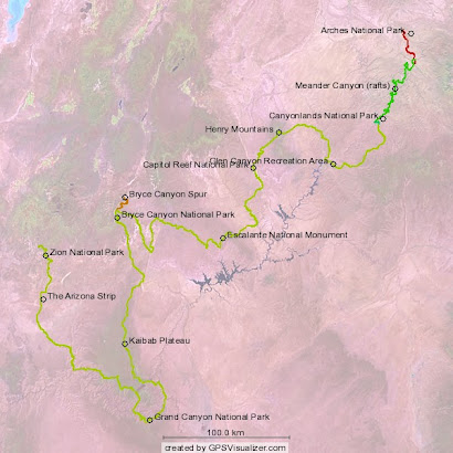

